 Download PDF
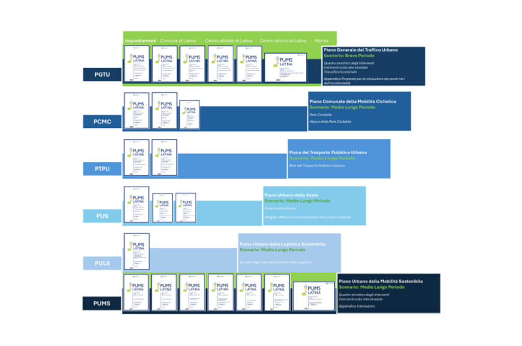
The assignment for the drafting of the Sustainable Urban Mobility Plan (SUMP) also included the update of the General Urban Traffic Plan (PGTU), the drafting of the Municipal Cycling Mobility Plan (PCMC), the Urban Parking Plan (PUS), the Urban Public Transport Plan (PTPU), and the Urban Sustainable Logistics Plan (PULS). Along with the drafting of the Plans, the related Strategic Environmental Assessment (SEA) procedures were carried out, as well as the planning and management of the participatory process.
The City of Latina’s SUMP, to improve the community’s quality of life, identified the following general goals:
- the promotion of an effective, efficient, and safe public transport service
- the implementation and connection of mobility infrastructures,
- the promotion of soft mobility through the intertwining of the main mobility axes and its strategic nodes with green and tree-lined areas,
- the organic connection of municipal pedestrian areas with large parks and poles of greater cultural attraction (and for leisure)
- the rationalization of the freight transport system together with the development of an urban context in which environmental and social qualities are ensured LG
The general objectives of the SUMP find their specific dimension in the various sector plans:
- Urban Public Transport Plan;
- General Urban Traffic Plan;
- Urban Parking Plan;
- Municipal Cycling Mobility Plan
- Urban Sustainable Logistics Plan
The guiding idea was to stitch the territory back together with a green, light, and adaptable, elastic and implementable fabric, on which the following intertwine:
- the connection between soft mobility systems – CL (pedestrian, cycling, etc.) and LPT hubs, in a context of green and tree-lined areas to achieve a high degree of attractiveness of active mobility;
- the promotion of cycling mobility as a tool for cultural and tourist enhancement;
- the optimization and efficiency of the road system and parking;
- the use of advanced technological systems that favor citizen involvement and consequently allow greater predisposition to the use of LPT;
- the rationalization of the logistics system on an urban scale.
A complex and articulated Plan in which the drafting of the SUMP master document has allowed to weave the mobility system through specific Plan tools, i.e. declining the actions for each area of intervention but maintaining the unitary guiding vision of the Plan.
The joint drafting of the SUMP and the PGTU has in fact constituted an important added value capable of giving the mobility governance action the ability to influence travel choices and mobility models in the short as in the long term according to a logic of mutual coherence.
This has, in fact, allowed to “design” the mobility of Latina adopting a multi-level orientation projected in the medium/long term (5/10 years of the SUMP) and defining strategies and policies in favor of transport sustainability starting from the short term.
This dynamic is intrinsic to the structure of the Sustainable Urban Mobility Plan of the City of Latina and of all the sector plans developed within it, a structure also recognizable in the graphic restitution of the Plan.
The measures taken in the Sustainable Urban Mobility Plan of Latina are oriented towards the construction of a sustainable future configuration for mobility, sustainability measurable in all its dimensions, social, environmental and economic, both in the individual measures and even more so in the combined and synergistic effect of the set of interventions.
The Municipal Cycling Mobility Plan, as well as the Urban Public Transport Plan, clearly highlight these objectives of the Plan and the paradigmatic synthesis is represented by the action introduced with the Urban Centralities that include in the same urban area, as a possible evolution of the “Smart services”:
- electric bike sharing stop
- electric car sharing stop
- electric BRT/LPT stop
- e-commerce delivery/collection box
- charging stations for electric vehicles, electric bicycles and scooters
- bicycle repair equipment
- information totem including charging socket for mobile phones, electric wheelchairs, electric scooters
- intelligent street lamps, including sensors, alarms and cameras (safety point)

The most significant and impactful Plan intervention is undoubtedly the introduction of a Bus Rapid Transit service between the station area (Latina Scalo), the city center, and the populous Southwest neighborhoods. This new, strong, and frequent local public transport axis becomes the new organizing axis of the entire mobility system.

New public transport lines for connection with FS Station and Circular Line
The modeling assessments of the Latina SUMP constitute the core of the Plan’s sustainability. Starting from the Current Scenario evaluations, the assessments were conducted for the Reference Scenario, the PGTU Scenario (i.e., Short-Term Plan Scenario – SPGTU), the Medium-Term Project Scenario (SPAMT), and the Long-Term Project Scenario (SALT).
The Reference Scenario is the scenario in which all short-term interventions already funded or under construction have been activated. Compared to the current state, this scenario presents some small road interventions on some network nodes, such as the insertion of some roundabouts. Observing the flowcharts and difference networks, it is evident how the impact of the planned and funded projects on the Latina network is very limited.
The PGTU Scenario is configured as the Short-Term Scenario, i.e., with a two-three-year time horizon. This scenario contains regulatory interventions, including the insertion of Cycling Zones within the historic center and the new parking tariff structure, and limited road interventions such as the insertion of roundabouts aimed at reducing accident black spots in the road network. From the flowcharts and difference networks between the various scenarios, it can be observed that the effect of the PGTU, although limited in values, mainly affects the increase of public transport in the central ring, as the central areas are those most affected by parking policies.
The Medium-Term Project Scenario (SPAMT) is configured as the scenario that adds the renewal of the public transport structure to the short-term interventions, in which the most impactful and significant intervention is the insertion of Bus Rapid Transit services. These changes are therefore already explicit and are added to the interventions simulated in the PGTU Scenario, thus ideally forming a chain of increasingly complex scenarios, both verifying and observing the effects of the various interventions in a cumulative perspective and illustrating the benefits considering the temporal evolution. The analysis of the flowcharts and difference networks for the Medium-Term Scenario shows how the introduction of the BRT line is able to attract a good number of passengers and not only on the BRT corridor but also from other areas as it makes the connection with the Station and with Q4Q5 easier, more frequent, and safer… In parallel, private vehicle flows are reduced especially in the southwestern arteries as local trips, towards the center and towards the station, are attracted by public transport made rapid, fast, and competitive by the new services.

Modal split and changes in the number of trips across different scenariosThe Long-Term Scenario is the scenario that, due to the complexity of solutions, implementation time, and the amount of funds needed, can only be implemented in a time horizon beyond the next five years. The solutions of the previous scenarios are still considered, and significant infrastructural interventions are added, such as the Latina North Ring Road and the infrastructural proposals on the Borgo Piave node to resolve congestion in access to the city from the West. The infrastructural solutions allow for a smoother flow of traffic, which can lead to an improvement in the performance of the automobile mobility system. However, the evolution and expansion of parking regulation policies and Cycling Zones are able to compensate for the attractiveness of private transport, avoiding the opposite modal shift and, indeed, increasing the number of passengers on public transport. Furthermore, the smoothing of traffic allows for better use of road capacity and, through a separation of road network functions, a reduction in the risk of accidents. The long-term passenger flowcharts show how, in the long term, public transport is able to attract a greater number of passengers, especially on the central ring and in the avenue system along the BRT corridor. The ring road system makes the BRT+Train combination for long-distance travel slightly less competitive; however, the difference is only a few units. The private transport flowcharts are dominated by the presence of large infrastructural interventions on the road network, such as the North Ring Road and the interventions in the Borgo Piave area to improve critical issues related to congestion and safety. The extension of Via Vespucci, from this point of view, which allows access to the Pontina from the city, is a strategic infrastructure for the purpose.
In partnership with Airis srl